Table of Contents
Online Help > Positioning
Positioning
The application is able to use the navigation satellite systems (GNSS) chip available in most devices and locate your real-time location on the map. Depending of your device capabilities, your location can be computed using the GPS, the GLONASS or the Galileo systems, or a mix of them.
The GNSS provides an usually precise location, and does not require cellular network coverage. However, it must have a clear access to the sky, meaning that it cannot be used indoor.
![]() If your device doesn't have any GNSS chip, or if this one is disabled in the Android settings, the network location (much less precise) may be used.
If your device doesn't have any GNSS chip, or if this one is disabled in the Android settings, the network location (much less precise) may be used.
To turn on the real-time positioning and display your location on the map, you can either:

- Long-press the “
Positioning” menu button;
 - Tap the “
Positioning” menu button, and on the “
Real-time position” toggle.
![]() The GNSS systems may require up to few minutes to retrieve your precise location after being turned on.
The GNSS systems may require up to few minutes to retrieve your precise location after being turned on.
The Positioning menu
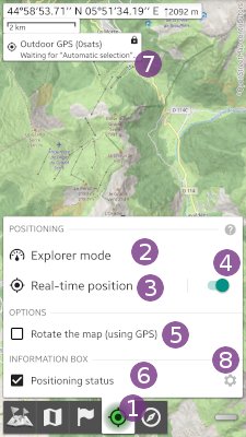
Tap the “Position” ![]() menu button to display the menu that contains:
menu button to display the menu that contains:
- “
Explorer mode” activate the Explorer mode with perspective view and dashboard;
 - “
Real-time position” displays the positioning details side-view;
Tap the “Options” to display the positioning options:
- “
Rotate the map (using GPS)” activates or deactivates the map rotation to make it match your current direction (you must be moving);
 - “
Positioning status” hides or displays of the top/left information box
  containing the most important positioning information. Tap on the settings wheel icon
  to choose what information to display at the screen center.
The menu icon
The “GPS position” menu button ![]() icon and color let you know the current state:
icon and color let you know the current state:
 When the icon is white, the GPS positioning is turned off. Long-press the button to turn it on.
 When the icon is green, the GPS positioning is turned on and the current location is displayed at the map center (or being retrieved). Long-press the button to turn it off.
 When the icon is green with a lock key, the GPS positioning is turned on and the current location is currently not displayed at the map center (you're looking somewhere else on the map). Click on the button to center the map on the current location.
The on-map positioning

When turned on, the GPS will try to compute your location based on the information retrieved from GPS satellites.
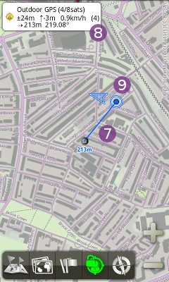
If the “Positioning status” option is checked, an information box ![]() lets you know how much satellites have been found yet. In this case,
lets you know how much satellites have been found yet. In this case, 4/8sats means that 8 satellites have been found in the sky, and 4 are being used to compute the current location. If 0 satellites are being used, then the current location has not been found yet.
If your current location has been found, this one is displayed in blue on the map ![]() . A circle indicates the area of precision (your real location is somewhere inside the circle, usually but not necessarily at the center). An arrow indicate your direction (while moving), and the information box
. A circle indicates the area of precision (your real location is somewhere inside the circle, usually but not necessarily at the center). An arrow indicate your direction (while moving), and the information box ![]() gives you the following information:
gives you the following information:
- The current location accuracy, its elevation, speed, and fix number;
- The distance and bearing to the map center (if different).
![]() In some cases, while retrieving the current location, the application can display an older one. In this case, this old location is displayed in red.
In some cases, while retrieving the current location, the application can display an older one. In this case, this old location is displayed in red.
![]() When the application is sent in the background (or when another one is started over), the positioning is temporarily deactivated to save the battery. This default behavior can be deactivated in the application settings.
When the application is sent in the background (or when another one is started over), the positioning is temporarily deactivated to save the battery. This default behavior can be deactivated in the application settings.
Elevations management
The elevation of a point is the difference between the altitude of this point and a reference surface of altitude 0 (also called “sea level”).
However, depending on what is considered to be the surface of reference, elevations can be quite different. This surface depends on the representation of the Earth, which has been shaped in many ways over the last centuries.
Many countries have used their own measure systems, defining representations that best match the surfaces of their own territories, and most of them are still used on paper maps. Unfortunately, as soon as used outside of their defined areas, these systems become inaccurate and useless.
The GPS, working worldwide, had to choose a system defining a shape that match the entire Earth. A particular oblate spheroid, called WGS84 has been chosen as shape, because it provides a good overall approximation while remaining simple.
Based on this choice, GPS's “WGS84” elevations are a good approximation at the Earth scale, but compared to per-country systems elevations, we can have discrepancies up to 50m.
To reduce these discrepancies and provide more precise elevations, the application convert all GPS elevations towards another system using a more precise shape of the Earth, called Geoid. However, some slight discrepancies can still be found.
![]() You can find a detailed article of the shape of the Earth on Wikipedia.
You can find a detailed article of the shape of the Earth on Wikipedia.